Publication | Streetscapes: Planning and Designing Vibrant Streets
Publication | Streetscapes: Planning and Designing Vibrant Streets

WHAT IS A STREETSCAPE?
Streetscapes can provide and support community visions for social interaction and achieve common goals such as safety, economic health, and social destinations. Streetscapes also contribute to lasting impressions of communities and places.
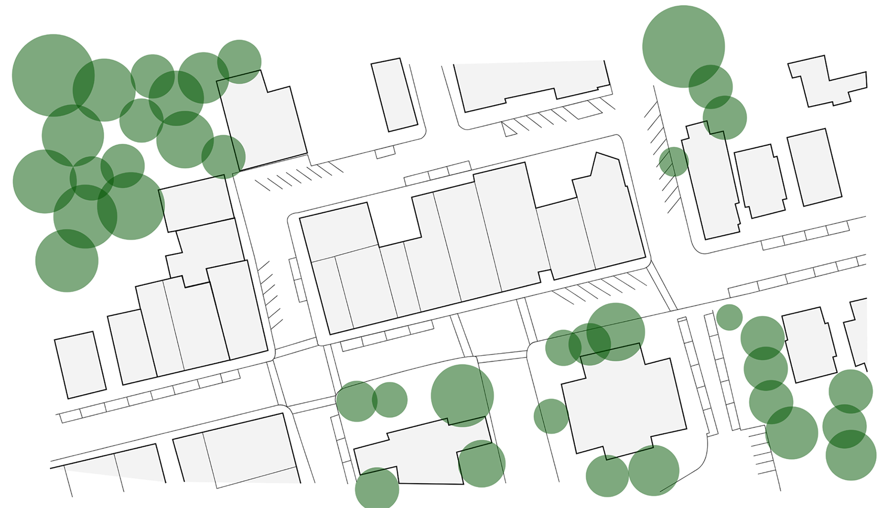
The streetscape development process requires community members to work together with local governments and other state and federal agencies that are responsible for creating and managing public right-of-ways (ROW), the property located edge to edge on either side of a street (Figure 1).
Figure 1
Streetscape environment and boundary expanding between properties on either side of the transportation corridor Source: Basemap Imagery USDA FSA NAIP, 2017
The planning process provides opportunities for collaboration and meaningful interaction among organizations, and strengthens community capacity.
Pleasant and safe streetscapes encourage individuals to use them for civic as well as economic activities and can lead to healthier lifestyles by providing alternative travel modes for everyday activities. Well thought out and designed streetscapes not only enhance the physical environment but also contribute to the community’s sense of place and place identity. For the purpose of this document, streetscapes will focus on urban design aspects for a street environment that includes and welcomes all types of travelers—pedestrians, cyclists, and drivers—as well as providing public amenities.
Streetscape planning and design is typically focused in the public realm since it generally occurs within the public right-of-ways (ROW). However, these projects also need to consider the private property adjacent to a potential streetscape project’s boundary. In fact, successful streetscapes are collaborative efforts that include property owners with parcels abutting the streets or with entrances from the streets. Communities can benefit from streetscape projects and the process of working in partnership. The ultimate goal of a streetscape project is to enhance quality of life by providing continuous experiences for users and activities. By partnering with property owners, the desired characteristics of the streetscape elements can be collaboratively discussed to develop a streetscape plan that not only enhances the quality of public space between facades but also considers the individual issues that property owners face. The involved partners, leaders, and stakeholders need to collaborate to create a set of guidelines that are appropriate to the scale and character of the places in which they will be implemented.
Streetscape projects should be planned to create and implement an environment that will be effectively used by the entire community through a range of travel modes. One street that many communities are continuously working to keep vibrant is “Main Street,” or the central hub area of traditional activity. In this document, the term “downtown” refers to the core part of a community where people regularly stop by or visit for everyday activities or errands, gatherings, or celebrations. A downtown streetscape is physically narrow and linear in nature and limited in space unless there is public space such as a park, plaza, or square integrated into the development pattern. In many Kentucky communities, the Main Street Program’s principles and approaches have supported and facilitated community efforts to value heritage, particularly in downtowns. However, not all communities’ Main Streets are eligible for guidance under such a program, which often has qualification criteria. The approaches and principles outlined in the program can still identify valuable steps for communities to follow. Whether or not your community qualifies for a Main Street Program, a community’s streetscape will benefit by a vision for vibrant streets.
HOW TO GET STARTED
There are two general ways to begin a streetscape project in a community. The first method is for the community (client) to hire design or planning professionals such as landscape architects, urban planners, or engineers to lead a streetscape project on behalf of the community. The second way involves a grassroots approach, where a community gets the project started and develops the conceptual ideas on their own, and then later during the design phase brings in professionals if needed. As a community development strategy, this publication focuses on the latter method—facilitated community discussions—to help projects get started. Collaboration, coordination, and partnerships are essential for the success of a streetscape project due to the complexity of street networks and the hierarchy of road statuses ranging from federal to local and private.
INVENTORY
A streetscape should be pleasant and welcoming for both community members and visitors, and clearly visible throughout the town. An ample number of signs must be visible to indicate relevant services to support positive experiences. Although the physical boundary of a streetscape may be limited, the public right-of-way—the extent of a streetscape that is experienced—includes the visible landscape beyond the public ROW (Figure 1).
To pursue the goals of a streetscape project, the key leaders gather information for the project area, including features that exist or are absent within the project boundary, and then define the scope and parameters of the project. Community leaders, extension agents, volunteers, and partners can then identify and inventory a range of data that will inform the decision makers of potential visions for the proposed streetscape(s).
An inventory of the existing streetscape’s features and conditions, as well as the physical, cultural, and socio-economic resources located in and around the project area, will help inform community members of the potential for and suitability of a streetscape design. The gathered information will provide insight to community members, partners, and design professionals throughout the decision-making and design processes. Often having existing and historical information about the uses, trends, incidents, and issues of the streets will help resolve potential conflicts and identify the type of streetscape considerations most suitable and feasible for the community.
Various factors along the route itself must be considered when planning and designing a streetscape project. The public, stakeholders, and partners must all be involved to build a streetscape that will be valued and used appropriately. Working groups must determine what level of streets are included in the projects—federal, state, local, or private— which will dictate restrictions and possibilities within the working boundary of the project.
Working groups should research the rules governing the different types of public ROWs as certain elements might be limited and others may be subject to negotiation. Information is often readily available at relevant offices in the local community such as the county or city offices of Planning and Zoning, Fiscal Court, historical societies, public libraries, or community newspapers as well as from individuals. In addition, any property owner who may be affected directly by the project should be consulted. Through a collaborative process and with a consistent aesthetic, a successful streetscape can become an effective connector between properties adjacent to the public ROW as well as other street networks in town.
The types of information needed for a streetscape project may be classified into the following categories: biological/ physical, social/economic and historical/cultural (Table 1).
Table 1. Inventory information and data for streetscape projects.
BIOLOGOICAL/PHYSICAL
- Maps of project location, restrictions, property boundaries, sidewalks, etc.
- Physical condition of built environments (widths, street amenities, utility infrastructure, etc.)
- Existing vegetation and wildlife
- Climate factors (local, regional)
- Preservation opportunities
- Signs of deterioration
SOCIAL/ECONOMIC
- Demographics of the community, county, region
- Economic indicators of the community, county, region
- Planning, regulations, standards documents (emphasis on transportation and economic activity goals)
- Types, locations and numbers of businesses
- Transportation documents, traffic counts, etc.
HISTORICAL/CULTURAL
- Historical maps, photos, documentation
- Community programs, regular or special events
- Activity trends along streets
- Landmarks, preserved elements
- Valued spaces, places, locations
- Main Street designation
- Historical/registered buildings/districts
This information ranges from topography, demographics, traffic counts, parking capacity, transportation planning documents, comprehensive plans, land use and zoning maps and ordinances, residences, and types of businesses, along with the locations of property boundaries. Once the relevant information is collected, the working group will better understand the opportunities/potentials and the constraints/limitations of a particular streetscape project.
BIOLOGICAL AND PHYSICAL INFORMATION
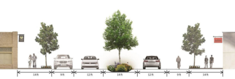
Biological and physical information includes data on natural resources, human influenced features, and infrastructure that can be historical or existing in the community. This information includes data on built environments such as roads, sidewalk networks, buildings, parking lots, utility lines, topography, and water-sewer systems as well as natural environment elements such as hydrology, vegetation, and wildlife species. These biological/physical infrastructure data are publicly available and accessible through local, regional, state, and federal level public offices and entities such as the Environment Cabinet, Kentucky Transportation Cabinet, U.S. Department of Agriculture, and U.S. Geological Survey, among others. The biological/ physical elements of a downtown form the boundaries of any streetscape project. Typically, the information is in the form of maps, GIS data files, aerial images, reports, or other documents and lists that support decision-making phases. Biological/physical data can provide context to the street network, the width of public ROWs, and locations of other infrastructure to consider. This data can also identify features that are suitable or problematic to support or include in the streetscape. Depending on the width of public ROWs, streetscapes may be restricted, limited, or challenged to include certain physical features and amenities. Surveys of street dimensions also inform the working group with locations of curbs and sidewalks, property boundaries and front facades, medians, and planting strips. Overall, this type of data informs us about where biotic and abiotic resources physically exist or do not exist and will directly affect the plans for the streetscape. Specifically relevant to streetscapes, the composition of various amenities will create different streetscapes that can offer strong or weak impressions of a community (Table 2, Figure 2).
Table 2. Detailed streetscape amenities
SIDEWALK AREA
- Sidewalks
- Crossing signals
- Trash cans
- Street trees and vegetation
- Wayfinding
- Tactile paving
- Pavement patterns
- Curbs
PRIVATE PROPERTY
- Signage on buildings
- Seating
- Planters
- Shade structure
CONNECTING
- Streetlights
- Crosswalks
- Marked bike lanes, paths or sharrows
- On-street parking space
- Median
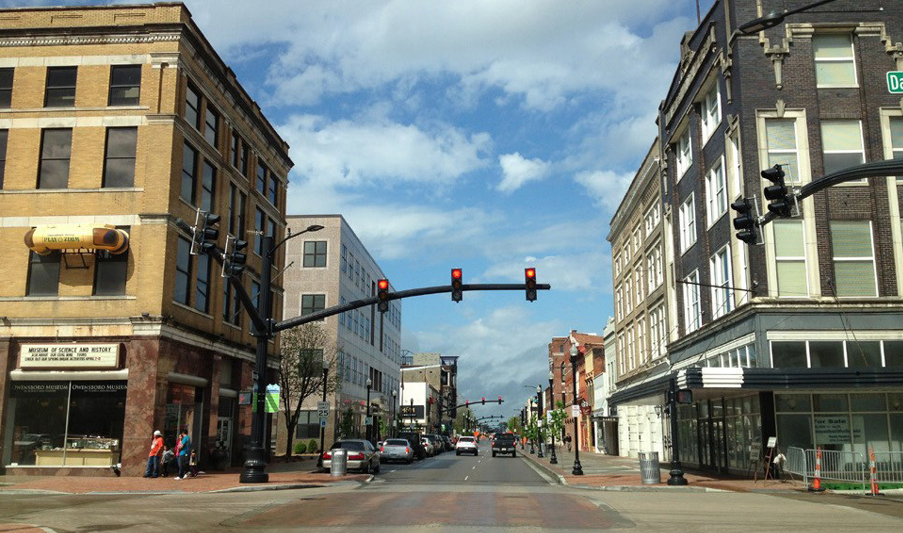
Figure 2
The streetscape environment includes, but is not limited to, transportation-related features and public amenities, such as those in Nicholasville, Kentucky.
SOCIAL AND ECONOMIC INFORMATION
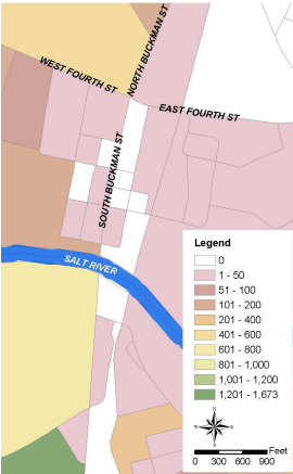
Social and economic data provide information about the people, households, and businesses that influence usage, issues, and trends such as demographic change, economic performances, and development activities. Population distribution, income levels, property/housing occupancy/vacancy rates, employment sectors, and new construction indicators are just some examples of this type of information (Figure 3).
Figure 3
2010 population map of Shepherdsville, Kentucky, in Bullitt County at block level at the intersection of main streets in downtown Shepherdsville (South and North Buckman Streets and West and East Fourth Streets) Source: U.S. Census Bureau, 2013
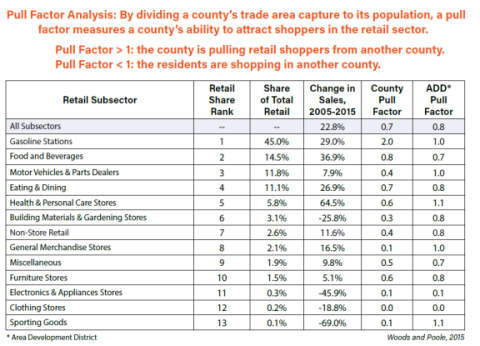
Social/economic information can be found through sources such as the U.S. Census Bureau, the Kentucky State Data Center, and the Kentucky Geography Network. In addition, local level data may be found in reports and documents available through community and economic development organizations or research groups. Information from these sources enables effective interpretation and prediction of the potential success of the community streetscape project(s). In addition, social and economic data offer user forecasts and information on indirect economic activities that can be generated or strengthened in communities and relate to the design quality of where the businesses may be located (Figure 4).
Figure 4
Local economy pull factors by retail subsectors in Bullitt County, Kentucky Source: Woods and Poole in CEDIK (Now Blueprint Kentucky)
HISTORICAL AND CULTURAL INFORMATION
Historical and cultural information provide a context concerning how and what has changed or remained the same in a community. Valuable data such as historic buildings, photos of events and festivals, and personal journals provide detailed information that may not be available through other sources. Events or places that might seem unimportant to some members of the community, such as locations of demolished buildings, heritage trees, or cultural activities, can add depth to the community project analysis or design (Figure 5).
Figure 5
A 1909 Sanborn Insurance map of Shepherdsville, Kentucky, in Bullitt County with original street names used in the past. (Main Street is now South Buckman Street, Water Street is First Street, and Walnut Street is now Frank E. Simon Avenue.) Source: Sanborn Map Company
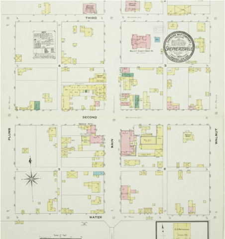
Furthermore, although some information may seem personal to a certain degree, it actually provides a sense of identity for the community. Therefore, these qualitative types of resources can indicate assets as well as strengths and weaknesses of the community and put these in a physical and temporal context.
ANALYSIS
Information gathered for the planning and design of potential streetscape projects can highlight important assets a community wishes to retain or reinstate. An analysis of the inventory data enables the working group to further understand how the community has changed physically, socially, and culturally. Similarly, it can help the group understand how the community has not changed, which can be just as important. The analysis process will better prepare the working group to address the future needs of their community.
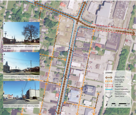
Once all relevant and available information is gathered and missing information identified, the working group will be able to analyze opportunities and constraints for the proposed streetscape project. A comprehensive analysis can lead to the identification of potential future uses for the streetscape as well as how the project can be effectively and efficiently implemented. Inventoried data such as traffic flow, pedestrian circulation, building usage and design, vegetation, and wildlife habitat can together help identify opportunities or constraints for a streetscape project (Figure 6).
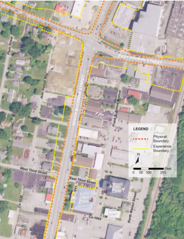
Figure 6
Context analysis map of South Buckman Street (US 61) and East 4th Street (US 44) in Shepherdsville, Kentucky Source: Basemap Imagery USDA FSA NAIP, 2017
Through the analysis, stakeholders have the opportunity to create safe, comfortable, and pleasant street environments that transition smoothly to the surrounding landscape, as well as to participate in meaningful decisions for the extended community. A thorough analysis can lead to a more effective streetscape plan or design that is more likely to be used regularly by people, a place where residents will frequent and visitors remember (Figure 7).
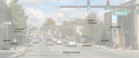
Figure 7
Proposed streetscape alternative in Shepherdsville, Kentucky, from three-lane auto traffic with street parking on both sides to three-lane auto traffic with a planting median and designated bike lane Illustration by Achan Sookying
CONCLUSION
Well thought out and completed streetscape projects can better support community visions that address a range of goals from strengthening social interaction to improving public safety, increasing economic activities, or lasting first impressions. Through the streetscape planning and development process, community members, local governments, and other state and federal agencies have opportunities to efficiently interact, collaborate, and strengthen their community capacity. With the development of sound streetscapes, community members will benefit from not only enhanced physical environments but also quality of life.
FURTHER RESOURCES
Smart Growth America, National Complete Streets Coalition http://www.smartgrowthamerica.org/complete-streets/a-to-z
Smart Growth America advocates for conscious efforts to improve growth patterns and development that previously resulted in low-density sprawl and resource consumptive behavior particularly as it relates to land use and transportation issues. The Complete Streets Coalition promotes educational material to consider and integrate ways for safer movement of pedestrians and vehicles with a focus on complete streets that include sidewalks, bike lanes, and extended crossings. The coalition provides resources, research findings, and guidelines for walkable and bikeable communities.
Kentucky Heritage Council, Kentucky Main Street Program http://www.heritage.ky.gov/mainstreet/
The Kentucky Heritage Council provides technical and design assistance, a resource center, national consultants, and grant funding opportunities for Kentucky Main Street Program participant communities that are working toward goals of historic preservation and downtown revitalization based on the four-point approach of the National Main Street Program of Organization, Promotion, Design, and Economic Vitality. As a primarily self-help program, communities are required to organize a volunteer board, commit to the project, and provide financial support.
REFERENCES
CEDIK (2016). Kentucky County Retail Sector Profiles: Bullitt County 2016. https://cedik.ca.uky.edu/data_profiles/retail_sector
Crankshaw, N. (2009). Creating Vibrant Public Spaces: Streetscape Design in Commercial and Historic Districts. Washington, DC; Covelo, CA; London, UK: Island Press. Dover, V., and J. Massengale (2014). Street Design: The Secret to Great Cities and Towns. Hoboken, NJ: John Wiley & Sons, Inc. Smart Growth America, National Complete Street Coalition (n.d.). Implementing complete streets: Sustainable complete streets. http://www.smartgrowthamerica.org\
Sanborn Map Company (1909). Sheet 1 of Shepherdsville, Bullitt County, Kentucky. http://kdl.kyvl.org/catalog/ xt7cz892885q_1/details.
U.S. Census Bureau (2013). Census 2010. http://ftp.kymartian.ky.gov/census/cenblock2010.zip
USDA FSA National Agriculture Imagery Program (NAIP) (2017). Kentucky Statewide 2 Foot Aerial Imagery (2016) - KY1Z. http://ftp.kymartian.ky.gov/FSA_NAIP_2016_2FT/
Download Formatted Publication
Related Information