Publication | Effective Navigation through Your Community: Wayfinding and Signage Systems for Communities
Publication | Effective Navigation through Your Community: Wayfinding and Signage Systems for Communities
WHAT IS WAYFINDING?
Welcome signs greet visitors to attractions, cities, towns, and rural areas. Could there be more ways to encourage visitors to further discover what a community has to offer? Whether traveling through or residing in an area, impressions and experiences of a community are important. Wayfinding is about making pleasant visual cues that can be understood and followed well by all people. When it is done effectively, wayfinding systems can benefit a community in many ways (Table 1).
Table 1. Wayfinding Project Benefits
INDIVIDUAL
- Clear view of community identity
- Provide guidance throughout the physical environment
- Strengthen sense of familiarity
- Highlight interesting destinations to explore
- Produce varied routes to experience
- Easily locate where one is in the community
COMMUNITY
- Create a strong sense of identity
- Ease travel leading to an increase in local economic activity
- Complement built structures
- Influence users in the built environment in relation to psychology, function, accessibility, and safety
Wayfinding is the ability to orient oneself based on repeated cues from the physical environment. Various physical features and structural elements can help people find their way around places, feel welcomed beyond the initial welcome sign at the entrance to a town or district, be informed, and feel helped when uneasy or lost. Residents typically already know their established paths to go from one destination to another. For visitors, uncertainty of how to reach a destination may discourage further exploration that could otherwise benefit a town. These uneasy experiences can change and become positive benefits for the community with effective wayfinding systems that complement the physical features in the built environment.
ORIGIN OF WAYFINDING
The wayfinding concept originates from the idea that our images of a built environment can be indicated by distinctive features of the environment that people remember such as landmarks. While there are people who are spatially well-oriented, there are others who are directionally challenged. Wayfinding should be expanded and approached from a community level. Helping a person make it through both unfamiliar and familiar environments can be simplified by addressing appropriate wayfinding needs effectively and efficiently (Table 2).
Table 2. Wayfinding definitions and goals for individuals and communities
INDIVIDUAL
Definition
- Ability to navigate through familiar or unfamiliar environment
Goal
- Comfortably travel through the landscape
- Navigate unfamiliar territory
- Navigate smoothly and avoid getting lost
Indirect Benefits
- Self-achievement
- Improve orientation skills
- Build a positive experience
Example: Louisville Loop Wayfinding Project Goals (Louisville, KY)
- Healthy recreational activities
- Informed travel through guided features
COMMUNITY
Definition
- Facilitation of travel through the community
Goal
- Support and inform positive resident/traveler experiences
- Unify environmental and cultural character/identity
- Create navigational experience
- Set clear environmental cues
- Effectively direct users to destinations
Indirect Benefits
- Provide positive experience of a community
- Increase economic activities
- Efficient navigation around town
- Promote healthier lifestyles through physical activities
Example: Louisville Loop Wayfinding Project Goals (Louisville, KY)
- Use trails and multiuse paths for everyday errands
- Present community identity (landmarks, store facades, etc.)
Wayfinding features within a community provide directional information. These features can further inform and educate people about the historic and cultural context surrounding a traveler’s environment while improving the overall experience. Travelers find their way around relatively unmarked routes by understanding geographic orientation, cardinal directions, and visual objects in unique settings. Natural or cultural landmarks such as a river, steep hill, or city hall can be applied to wayfinding in cities and communities to help travelers become familiar with their route and support effective and educational navigation for travelers to their ultimate destination.
A challenge of smaller communities and their built environments can be the lack of customary environmental cues for visitors such as street signs or named streets. In such communities, residents already know where everything is located and therefore do not feel it necessary to enhance cues. However, a lack of wayfinding elements can present an uninviting atmosphere for visitors, the very people many communities are striving to attract for tourism and economic activity. Furthermore, aging infrastructure can present disorganized and uncoordinated signs that detract users from the environment, and potential confusion for visitors and residents. Wayfinding is a problem solving skill that requires both the individual’s ability and the environmental setting to be set up to work together in a holistic way. This skill to recognize one’s way around their environment involves three steps to successfully reach one’s destination (Figure 1).
Figure 1. Integrated relationship between an individual’s wayfinding ability and a signage system within the a community’s built environment.
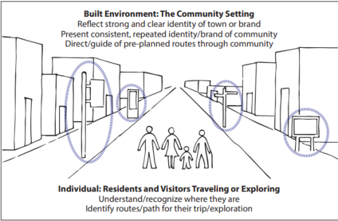
First, one needs to make the decision of their purpose or destination and how to reach it. Second, one needs to execute their plan while processing the information around them along their route. Third, one needs to actually find their way to the location. These three steps are interrelated, need to be processed together, and are dependent on the community’s physical environment.
CONCLUSION
Wayfinding planning and design projects are most effective when community members work together to help their residents and potential visitors make their trips and explorations efficient. When done effectively, all persons can benefit from having a wayfinding system in place. The community system can reduce the potential for getting lost even within a familiar setting and strategically improve livability. A successful wayfinding system can influence the travel experience and a community’s identity through a range of features and characteristics appropriate and representative for its physical setting. Signage systems are explicit communication tools to facilitate navigation and reflect cultural features while complementing a community’s physical environment.
A well-designed wayfinding system can convey information effectively and have a positive impact on both individuals and the community through increased comfort and awareness of the users as well as increased visibility for attractions and local businesses. When environmental cues are effectively reinforced and restated, an individual’s ability and skill to navigate and experience the community environment can be enhanced.
Further Reading in the Wayfinding Series:
- Wayfinding: Planning and Design with Communities
- Wayfinding: Planning and Design at Work
If your community is interested in planning or designing a wayfinding system, please contact the author.
REFERENCES
Arthur, P. and Passini, R. (2002). Wayfinding: people, signs, and architecture (Limited Commemorative Edition). Ontario, Canada: Focus Strategic Communications.
Lynch, K. (1960). The Image of the City. Cambridge, MA: MIT Press.
Moreville, P. (2005). Ambient Findability: What We Find Changes Who We Become (1st Edition). Sebastopol, CA: O'Reilly Media, Inc.
Related Information